2013 Winter Recap
Our prediction of cooler-than-normal winter temperatures east of the Rockies came to fruition as seen in Figure 1 below. The core of the anomalously cold temperatures was centered over the western Great Lakes and into the northern Plains. Cooler temperatures spread as far south as Texas, as was predicted. Additionally, our forecast of anomalously cool temperatures throughout the season also came to fruition as cool anomalies were seen from November through February and into March. All in all, our Winter prediction was a success.
Summer 2014
As we progress towards summer, more and more climate models are calling for a developing El Nino situation. If you recall, El Nino is characterized by an anomalously warm pool of water that migrates from the western tropical Pacific Ocean to the eastern tropical Pacific. As a result of this displacement, “normal” worldwide weather patterns are disrupted in that the area of enhanced convection is displaced towards Central and South America, thus influencing the location of the jet stream.
In the United States, although El Nino effects are strongest during winter, summer weather patterns will be somewhat impacted because of the changing jet stream patterns due to the anomalous position of tropical convection. This should result in enhanced precipitation west of the Rockies this summer. This particular area is currently experiencing a very severe drought and the rains will be welcome, especially by the agricultural and water-utility planning communities.
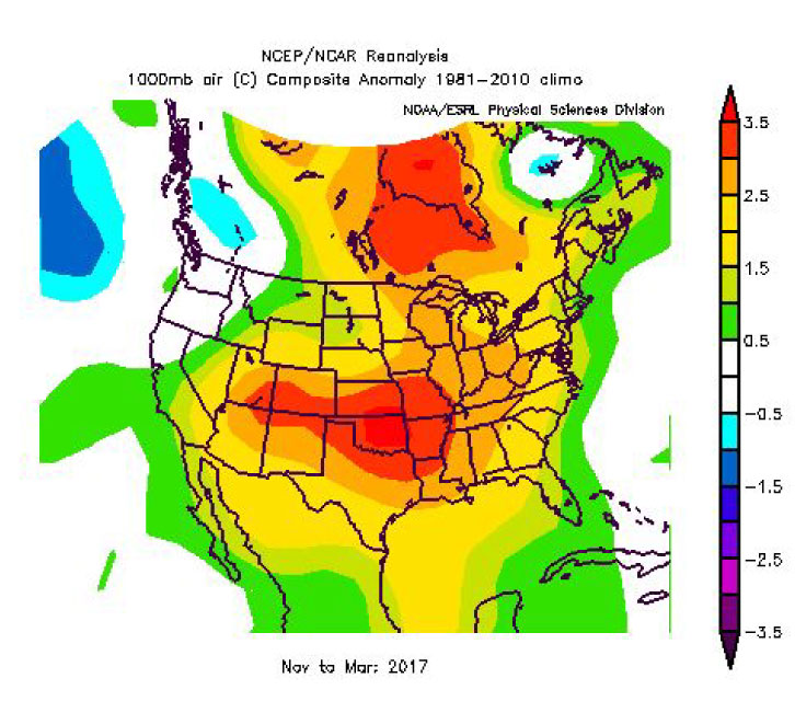
For this summer (May-Sep), Esco Advisors is predicting a cooler-than-normal temperature regime across much of the United States with a dipole of significantly cooler temperatures (2 degrees F or more) in the northeastern and southwestern quadrants of the country. (fig 2)
Precipitation, while enhanced west of the Rockies, will be decreased east of the Rockies, especially from the western Great Lakes through the Ohio Valley, into the Mid-Atlantic and north through New England. The only areas east of the Rockies that we foresee with the potential for enhanced precipitation are Texas and the Florida peninsula.
Tropical Outlook
The developing El Nino will most likely depress tropical storm/hurricane activity due to increased wind shear. According to The National Hurricane Center, a “normal “ year in the Atlantic / Gulf of Mexico/ Caribbean will see 11 named storms with 6 being classified as hurricanes. Our analysis shows a likely outcome of 8 named storms with 4 reaching hurricane status for the 2014 season. More importantly, we feel that the East Coast (including the east coast of Florida) is more than twice as likely as the Gulf Coast to be impacted by tropical activity (Cape Verde storms). With respect to the Gulf Coast, we feel that the western Gulf has a better chance of seeing tropical activity than the eastern Gulf due to its closer proximity to the region of the enhanced convection and, hence, locally originated storms. Another difference between the East Coast and Gulf Coast that we should see this tropical season lies in the intensity difference between the Cape Verde storms and the “locally originated” ones. Because of the “time over water” and the distance to be covered, the Cape Verde storms have a far greater chance of becoming major hurricanes.
NOTE: ESCOWare® and ESCO Advisors™ provide this information as a courtesy to enhance the risk management process and are not responsible for the accuracy of this forecast and/or actions taken as a result of this forecast.