 By Ian Palao | Director of Analytics
Many of you have probably read or heard about the news article where the author stated that La Niña “is virtually a sure thing to happen within the next half year”. I know that I have been asked about it by clients and coworkers alike. In the article, the author describes how this strong El Niño (which it most definitely is, as measured by sea surface temperatures) will most surely be followed by La Niña sometime before Summer 2016. The author bases his views on two things…..the fact of the Niña that followed the 1997/98 Niño and a few current climate model runs that dive into the Niña realm.
In my opinion, that article smacks of sensationalism. First, just because La Niña followed the strong El Niño of 1997/98 (a fact), does not mean that a La Niña will automatically follow the strong El Niño of 2015/16. Secondly, the majority of climate models ARE NOT calling for a La Niña, much less a “killer La Niña” as was stated in the report.
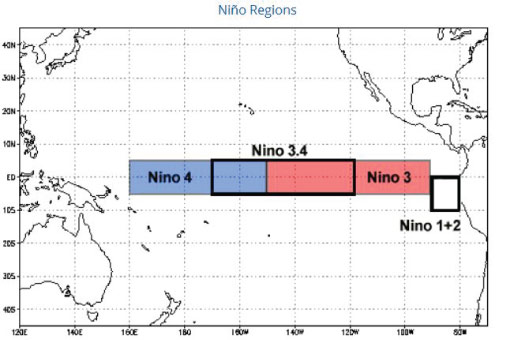
First off, let me present a little information as to how El Niño and La Nina are classified. An El Niño (La Nina) is classified as such when the sea surface temperature anomaly in the Niño 3.4 region (figure 1) is at least +0.5C (-0.5C) from normal for 5 consecutive, 3-month moving periods. Currently, the latest 3-month measure is +1.7C, far above the El Niño threshold and far above climatological normal for this time of year.
FIGURE 1
As of now, as seen in figure 2, it is obvious that the majority of models are calling for an end to the Niño conditions by summer (nothing new there) and that most end up in the “neutral” or “weak Niño” range. To aid in quantifying these models, the Australian Bureau of Meteorology, as of Nov 22, is stating that, by June 2016, 58%, 36%, & 6% chances exist for neutral conditions, El Niño conditions, and La Nina conditions, respectively. Six percent?? That is far from a “sure thing”.
FIGURE 2
Yes, there are SOME models that forecast sea surface temperature anomalies in the Niño 3.4 region to be in the Nina realm by summer. But only 4 do so at the moment. If, as we progress into 2016, more and more models are falling into the Niña range, then yes, it would be more than reasonable to begin reporting about the potential for La Niña and the associated impacts such as increased tropical activity in the Atlantic/Caribbean basin.
Until that happens, to do so with certainty is only sensationalism as scientific thought is not supportive at the moment. In my opinion, our clients should not, at this moment, strategize around a “certain, killer La Niña” for Summer 2016.
NOTE: ESCOWare® and ESCO Advisors™ provide this information as a courtesy to enhance the risk management process and are not responsible for the accuracy of this forecast and/or actions taken as a result of this forecast information.
For more information about the products and services of ESCO Advisors and ESCOWare, please contact Irv Lebovics at 203-456-1833.

Share this
How Extreme Weather Impacts Your Portfolio...
ESCO Advisors™ 2014 Summer Forecast...